Tag Archives: Mississippi River

Top 10 posts of 2011 for Joe Spake’s Weblog

Panororama of Flood

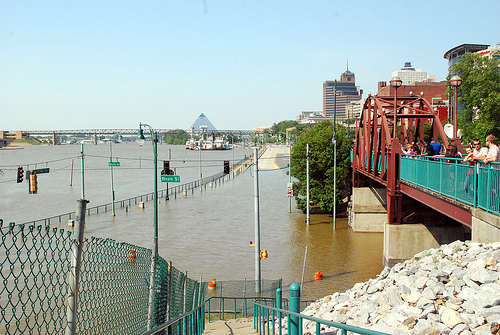
Panorama of Mississippi River flood crest at Memphis - May, 2011

Disaster sells, obviously

Four of the most read posts on Joe Spake’s Weblog in 2011 were directly related to this year’s record flooding on the Mississippi River from the Memphis perspective.  Interestingly the 6th most read post, about the Memphis ice storm of 1994, was written in January of 2010, and has been read consistently ever since (Maybe I accidentally worked some SEO magic.)  Here are the Joe Spake’s Weblog Top 10 for 2011:

1.  Mississippi River flooding- You ain’t seen nothing yet  (April 4, 2011)  – The water was high in April, but not nearly as high as it would be in May.

2.  Flood Stage (April 26, 2011)   – Actually the Mississippi River rose over 14 feet higher than the official “flood stage”.

3.  NOAA raises Memphis flood crest prediction to 48 feet (May 2, 2011)

4.  Why I am not following you back on Twitter  (June 19, 2011)   – It seems that everyone wants to get involved in Twitter, but few want to put forth the effort to engage.  Think back to how much Twitter has been in the news, or actually shaped news in 2011.  The growth of the 140 character messaging system will continue.

5.  Quick guide to Mississippi River Conditions  (January 31, 2011)   – Written before the magnitude of the flood was anticipated.

Continue reading

Old Man River just keeps rollin’ along

May, 2011

On May 10,2011, the Mississippi River at Memphis, Tennessee crested at 48.03 feet as reported by the National Weather Service.  The flood was the second highest in recorded history, topped only by the flood of 1937.  Many homes were flooded on the outskirts of the city;  Riverside Drive and the west end of  Beale St., and Tom Lee Park were flooded;   much of Mud Island Park was submerged.   Here is my post from May 29.   And here is a slideshow of photos I took during the flood:

October, 2011

The River was at a low ebb on October 13, 2011 – 0.10 feet on the Memphis Gauge –  48 feet lower vertically than in May, the difference in height equivalent to a 4 story building.  In the next few days the river stage dropped to -2 feet before starting to rise some.  Zero does not mean the River is empty – that is just the benchmark for low water, a point that navigation can be affected.  The record low water at Memphis was -10.7 feet in 1988.  The River and riverfront look quite different at low water.  The cobblestone bank runs out, sandbars, and river current control structures, pile and rock dikes are clearly visible.  Seeing the river at this low stage, it’s hard to even imagine what it looked like in May.  Here is a slide show:


The Great Memphis Flood of 2011

Memphis Flood 2011 47.19 Beale St (7)

Riverside Drive and Beale Street

Friday,  May 27, the Mississippi River at Memphis dropped below the flood stage of 34 feet for the first time since April 26, 2011.  The picture above was taken at the River’s crest of 47.8 feet, the second highest in recorded history.  The area still has a massive cleanup ahead.  Many homes are total losses, uninhabitable, or face extensive repairs.   Memphis seems to be returning back to normal, as evidenced by the reopening of Tom Lee park, which was inundated 2 weeks ago, for Memphis in May’s final event, the Sunset Symphony. Continue reading

Related Posts Plugin for WordPress, Blogger...